
A remote and historic valley with a single access road, notorious for its dangerous climb across a nearly 3000 metres high pass, are just the ingredients one needs to put a trip to Tusheti on the “must do” list of places to visit in Georgia. Finally, in summer 2017, it was the moment to exchange the “must do” into “done”. An amazing and thrilling experience.
Even though it fell under the Georgian Kingdom Kartli-Kakheti, until the late 17th century Tusheti was effectively autonomous as a “tribal democracy”. Not very hard to imagine knowing how remote it is from the rest of Kakheti. The region has been subject of foreign invasions however, from the Mongols to the Persians, and more regionally, Dagestani tribes.
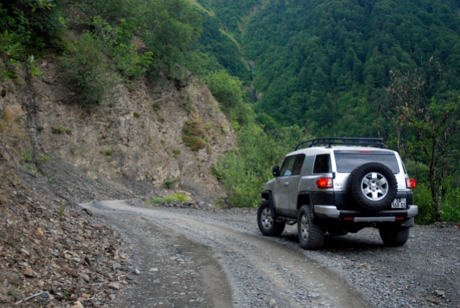
Dirt track
So, where is Tusheti located? The northeast part of the country, in the high parts of the Caucasus Mountains bordering the Russian Federation (Chechnya and Dagestan Republics). Until the early 1980s the valley was only accessible by horse or walking track, when in 1982 the road opened. The 72 km to Omalo (E in map), the main village in Tusheti, starts from the village of Pshaveli, at the foot of the mountains in the Alazani River Valley (D in the map below). The route takes the driver across the Abano Pass, the highest drive-able pass in the Caucasus Mountains.
The road featured in the 2013 season of the BBC series “World’s Most Dangerous Roads”. Due to the extremely steep mountain slopes the road is narrow, mostly a single car wide, and it is very exposed to landslides and other natural forces. From October to May-June the road is closed, and the valley is inaccessible. Most of the road is in a notoriously bad shape. Nowadays most Tusheti residents leave the valley for winter, living in Kakheti.

The Trip
If the above doesn’t sound exciting enough, planning is adding to that! Obviously one needs a 4WD car with good ground clearance, so we decided to rent a Toyota FJ Cruiser from Cars4Rent. Tusheti Valley is popular with hiking tourists, and there are plenty of guesthouses. Most of them are situated in Kvemo (Lower) Omalo and Zemo (Upper) Omalo, with more guesthouses in villages such as Dartlo, Shenako, Diklo and Girevi. The guesthouses mostly cater to eco-tourism, hiking and horse riding. We contacted Guesthouse Shina in Upper Omalo to reserve for a few nights. It has a good location right under the Keselo fortress.
Kakheti
Leaving in the early morning from Tbilisi we take the S5 Kakheti Highway to Sighnaghi. This historic fortified town is located in the southeastern stretch of the Gombori Mountains, and has an amazing view over the Alazani River Valley. On a good and clear day one can see the Caucasus mountain range all the way into Azerbaijan. Sighnaghi, historic and touristic as it is, is a good place for a coffee or lunch stop.

We continue our way into the Alazani Valley, the wine basket of the Kakheti province, with a lot of villages bearing the names of Georgian wines. Following the Sh42 road along the foot of the Gombori range we arrive in Telavi, another compact historic town. Once the capital of the (Georgian) Kingdom of Kakheti, now a regional administrative centre. Next to the statue and fort of King Erekle II we have lunch in the peaceful garden of the excellent Mala’s Garden restaurant.

Road to Omalo
Time to get on with it! From Telavi we take the Sh70 across the Alazani River, a beautiful road between big trees. At the river people are enjoying the summer weather, with cars parked in the river bed. Following the Sh43 through wine village Napareuli, we get to Pshaveli and take the turn into the Sh44 road to Omalo. The first 10 of the 72 km to Omalo is quite smooth on decent asphalt, but then the gravel sets in. At first nice, rather wide along the Stori River, but after another 10 km or so the river valley closes in, into a gorge, driving next to rock cliffs on one side, and a steep drop on the other, in a lush green environment. From here regular 2WD passenger cars can experience road problems. With the exposed rocks, stones dropping on the road, and water falling down the road surface is getting rough. But quite manageable.
At the 25 km mark, after crossing the river across a steel bridge the first steep climb starts, climbing 500 meters through 6 hairpins. Now the road gets tough, rough, very narrow and steep at places. There are a few slightly wider sections that can serve as tight passing points and you have to be on guard for oncoming traffic. After this first serious ascent, the road winds for a few kilometers along the mountain slope with beautiful views driving next to a sheer drop, to reach at 36 km the final ascent to the Abano Pass, climbing another 500 meters in 7 hairpin turns, reaching the pass at the 41 km mark.
Descent
The descent is as challenging as the ascent. Just like going up, the road winds down in a few (hairpin) staircases into the valley. We meet a Tush shepherd with his huge flock of sheep, and continue the road, at first steep while following the upper flows of the Satskhvrekhorkhi River. The river flows towards the Russian Republic of Dagestan and into the Caspian Sea. The Abano Pass is a watershed, so all the rivers here flow to Russia. Since we are on the north side of the Caucasus Mountains, there are still patches of snow left.

Just past a ranger station at 52km the river becomes like a lake in the gorge, and the road is just about getting flooded. It appears that further down the river is blocked due to massive rocks. The result is amazing though: turquoise colored water with tree tops sticking out of the water. At the 58 km mark we get into a local junction at the village of Khiso. We continue our road towards Omalo, crossing the river. At 63 km we let the river continue its way to Dagestan, while we take a steep hairpin climb to the plateau where Omalo strategically is located. After a few more kilometers we reach Zemo Omalo and our guesthouse Shina. A job well done.
Omalo
The village is very compact with a few dozen houses overlooked by the 13th century Keselo fortress. The fortress was originally built to protect the people against the Mongol invasion, and later used to protect the Tush against invading Dagestani tribes. From 2003 five of the original thirteen towers have been rebuilt on the initiative of a Dutch family living in Georgia. When the road to Omalo was constructed, electricity lines were also constructed parallel to the road to provide the valley with power. Since then, due to geographic and climate circumstances, and the poor state of independent Georgia in the 1990s the power cables have become defunct, and have not been repaired. Therefore, in Tusheti there is no regular power, nor hot water. Power is generated by solar energy.

In Zemo Omalo, and thus in our guesthouse, we had power (and very crucial wifi!) in evening time and hot water at very limited time slots. Shina Guesthouse provides full pension, meaning breakfast and diner. There is no menu, so you eat what they cook. Very friendly and dedicated staff. Unfortunately we were not lucky with the weather when we were there. It was cold, cloudy and with slight rain sometimes.
Dartlo
The road into Tusheti continues after Omalo, and goes to Dartlo, and even continues until Girevi, roughly its terminus. From here hikers can continue walking for about 3 days until they reach Shatili in Upper Khevsureti, at the Chechnya border. Th ehiking trail crosses the Atsunta Pass at a staggering 3430 metres above sea level. There are plans in Georgia to connect Tusheti and Shatili by road for tourist purposes. Locally there is no demand for such a road, and there is some protest against it. Dartlo is just a relatively easy 30-40 minute drive from Omalo. Just before arriving in Dartlo the valley opens up. In Dartlo there are also a few defensive towers, and the ruins of an old abandoned church.

In the valley the OSCE had a Border Monitoring Misison from 1999 to 2004, monitoring the border with Chechnya. It was launched after Russia accused Georgia of hosting Chechen terrorists on its territory, in the Tusheti en Khevsureti (Shatili) regions and violated the Georgian air space a couple of times, firing at border posts and villages. The follow up projects were terminated in 2009 after Russia withdrew its support for extension of the mandate.
The road from Omalo
As pictures say more than just words, here is a compilation of the road from Omalo back to Kakheti. To compact it a little, the speed is 1.25x the original (slightly faster).
Dartlo road
The summarized road video of the Omalo to Dartlo section. Driving section 1.25x speed of the original (slightly faster).